
LIDAR Used for Point Cloud Elevation Mapping
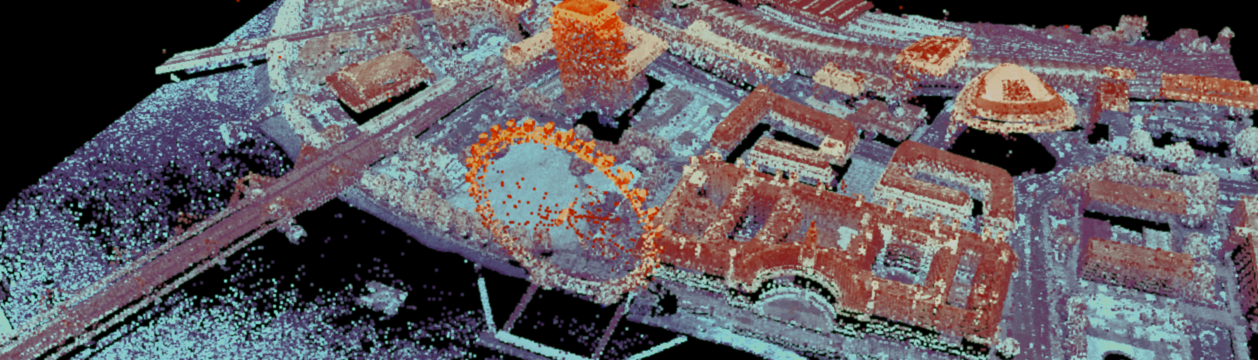
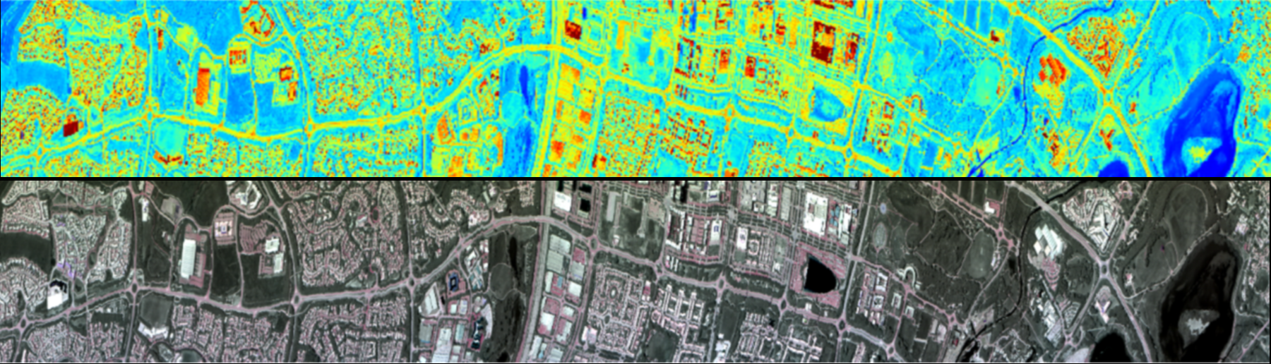
LiDAR over our main geospatial test site at Alconbury, UK. The image shows the resultant point cloud data after post-processing.


The TeleDyne Optech Galaxy T2000 is a highly dynamic LiDAR system, capable of both narrow corridor surveying and wide-area mapping. LiDAR is established as a highly effective method of creating dense and accurate elevation data across landscape and shallow-water terrain.
The galaxy has a class IV laser with a programmable pulse repetition frequency (PRF) of 50khz to 2Mhz. The high PRF enables fast data acquisition, providing a very high point density. Each pulse can have up to 8 returns allowing detailed vertical resolution of complex targets, such as tree canopies. The point density can be increased further through lowering the FOV. The powerful class IV laser allows for the Galaxy to be effective up to 6000m altitude, creating greater swath widths.
The Galaxy utilises PulseTRAKTM and SwathTRAKTM. PulseTRAKTM effectively removes blindzones, maintaining consistent point density and eliminates the impacts of atmospherics in ground model results. SwathTRAKTM is able to modify the scanning FOV during collection to maintain fixed swath widths and even point distribution over rugged terrain. LiDARs with fixed FOVs struggle to maintain steady point distribution over variable terrain like mountain ranges, which often requires mutliple flights over the same swath. The combination of SwathTRAKTM and the galaxies maximum flying height allow for greater swath widths and point density, reducing the number of flight lines needed, decreasing flight time and costs.
LiDAR over our main geospatial test site at Alconbury, UK. The image shows the resultant point cloud data after post-processing.
Everett, A et al., (2021). The impacts of a subglacial discharge plume on calving, submarine melting, and mélange mass loss at Helheim Glacier, south east Greenland. Journal of Geophysical Research: Earth Surface, 126(3), p.e2020JF005910.
Marselis, S.M et al., (2020). Evaluating the potential of full-waveform lidar for mapping pan-tropical tree species richness. Global Ecology and Biogeography, 29(10), pp.1799-1816.
Simonson, W et al., (2016). Modelling above-ground carbon dynamics using multi-temporal airborne lidar: insights from a Mediterranean woodland. Biogeosciences, 13(4), pp.961-973.
| Range Performance | 150-6000m AGL |
| Absolute Horizontal Accuracy | 1/10,000 x altitude |
| Absolute elevation accuracy | < 0.03-0.25 m RMSE from 150-6000m AGL |
| Topographic Laser | 1064-nm near-infrared |
| Laser Classification | Class IV |
| Pulse Repetition Frequency | Programmable, 50-2000kHz |
| Beam Divergence | 0.16 mrad (1/e) or 0.23 mrad(1/e2) |
| Laser Range Precision | < 0.008m |
| Minimum target seperation distance | < 0.7 m (discrete) |
| Range Capture | up to 8 range measurements |
| Intensity Capture | up to 8 intensity measurements |
| Positon and Orientation system | POS AV™ AP60 (OEM); 220-channel dual frequency GNSS receiver; GNSS airborne antenna with Iridium filters; high-accuracy AIMU (Type 57); non-ITAR |
| Scan Angle (FOV) | 10-60° 6 |
| Maximum Scan Frequency | 320 scan lines/sec 1 |
| Flight Management System | Optech FMS (Airborne Mission Manager and Nav) with operator console |
| SwathTRAK | Dynamic FOV for fixed-width data swaths in variable terrain |
| PulseTRAK | Multipulse tracking algorithm with no density loss across PIA transition zones |
| Roll Compensation | ±5° minimum |
| Data Storage | Removable SSD (primary); internal SSD (spare) |
| Power Requirements | 28 V; 400 W |
King’s College London, Bush House (NE wing), 30 Aldwych, London, WC2B 4BG