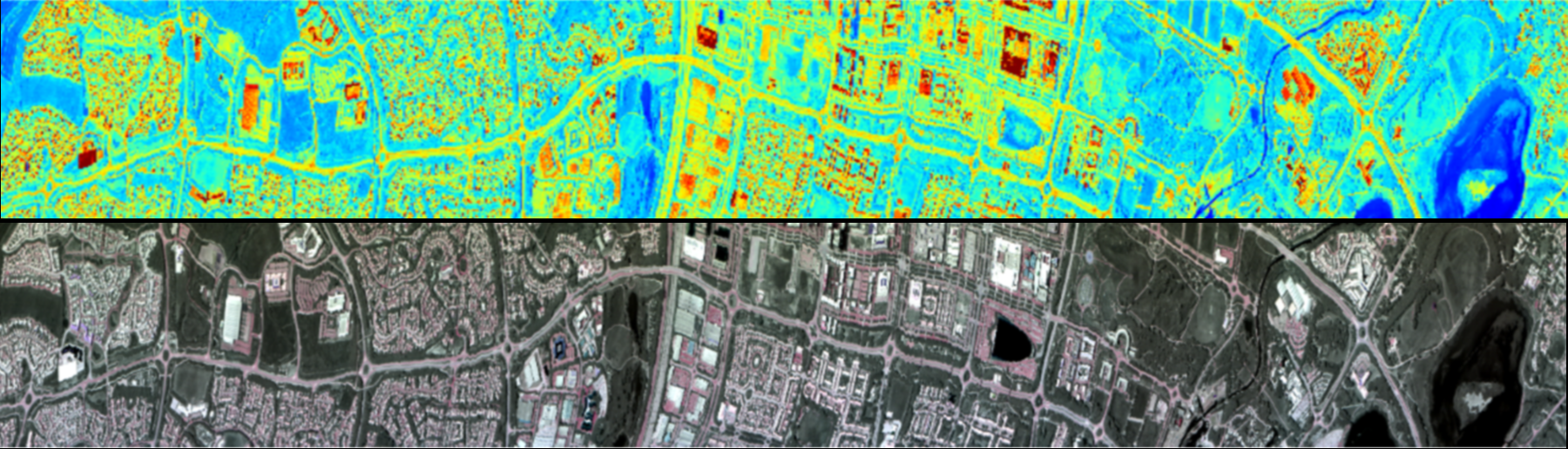
Optical Hyperspectral Imagers

PLACEHOLDER IMAGE

FENIX 1k

The FENIX 1k is a hyperspectral imager covering the visible, near infrared and shortwave infared region (380- 2500 nm) in 594 spectral bands at 2.8 to 8nm spectral resolution.

Co-registered data in all wavebands are provided at a pixel size of less than 0.5 m from a 1 km flying height, and higher spatial resolutions can be gained by flying at lower altitudes. The FENIX 1K has 1024 spatial pixels, compared with the 384 of its forerunner, the FENIX, making it a more productive sensor. It produces the same top quality full-spectrum hyperspectral data as the FENIX, whilst being able to use fewer flight lines as well as collecting data with greater accuracy. Applications include Vegetation Analysis, Precision Agriculture, Environmental Monitoring, Detection of Invasive Species and Invasive Insects on native species as well as Mining and Mineral Mapping/Geological Exploration.

Applications

Fenix comparison
Fenix vs Fenix 1k

Side by side comparison of FENIX and FENIX 1K data measured at the same location, Milton Keynes, UK. This false colour composite using wavelengths in the NIR, Red and Green portions of the spectrum highlights productive vegetation in red, with the new FENIX 1K sensor able to show variation within individual trees.

Example Publications

Carmon, N. and Ben-Dor, E., 2018. Mapping asphaltic roads’ skid resistance using imaging spectroscopy. Remote Sensing10(3), p.430.

Xie, R., et al., (2021). Mapping leaf area index in a mixed temperate forest using Fenix airborne hyperspectral data and Gaussian processes regression. International Journal of Applied Earth Observation and Geoinformation95, p.102242.

Pelta, R., et al. (2019). A machine learning approach to detect crude oil contamination in a real scenario using hyperspectral remote sensing. International Journal of Applied Earth Observation and Geoinformation82, p.101901.

FENIX

The FENIX is a hyperspectral imager covering the visible, near infrared and shortwave infared region (380- 2500 nm) in 594 spectral bands at 3.5 to 10 nm spectral resolution.

Co-registered data in all wavebands are provided at a pixel size of less than 1 m from a 1 km flying height, and higher spatial resolutions can be gained by flying at lower altitudes. It is the forerunner of the Fenix 1k sensor (above) and whilst most characteristics are somewhat less capable than the 1k version, it does have some advantages with regards to detector saturation and possibly signal to noise (as pixels are larger and collect more light per pixel). Most uses are related to land surface imaging of solar reflected radiation, supporting applications such as land-cover mapping, vegetation cover and species discrimination, vegetation health assessment, geological investigations etc – but its data can also support studies of ocean colour, water pollution and hot object (e.g. fires, volcanoes) thermal emission.

Applications

Slide
FENIX Mosaic

FENIX Data collected over grosetto, Italy as part of the 2019 HyTes Campaign, in collaboration with NASA-JPL

Example Publications

Lee, J., et al. (2016) Individual tree species classification from airborne multisensor imagery using robust PCAIEEE Journal of Selected Topics in Applied Earth Observations and Remote Sensing9(6), pp.2554-2567.

Pullanagari, R.R., et al., (2016) Mapping of macro and micro nutrients of mixed pastures using airborne AisaFENIX hyperspectral imagery. ISPRS Journal of Photogrammetry and Remote Sensing117, pp.1-10.

Bellinaso, H., et al., (2021) Clay content prediction using spectra data collected from the ground to space platforms in a smallholder tropical area. Geoderma399, p.115116.

Contact Info

King’s College London, Bush House (NE wing), 30 Aldwych, London, WC2B 4BG

martin.wooster@kcl.ac.uk

@KCLwildfire_EO